Author: Chu-Chung Chen, Argricultural Chemistry Division, Taiwan Agricultural Research Institute
The traceability record has been getting important in agricultural production to serve as a critical tool to avoid or clarify the food safety issues, ensuring the consumers’ safety and reducing the risk of hazards along the supply chain. The main agricultural traceability programs currently run in domestic market are Taiwan Agriculture and Food Traceability program (TAP) and Certified Agricultural Standards (CAS). As to the agricultural products to export, the international costumers request the traceability records following Global Good Agricultural Practice (Global G.A.P.) or related program. The requirement of Global G.A.P. is comprised of detail records of environmental monitoring and maintenance, field management in each planting site; also the field survey from certification body were conducted periodically. The paper works in the certification process have rendered a heavy loading for the producer. Usually the formats and regulations are dissimilar in different certification system; for example, the electronic record is acceptable for Global G.A.P but not for MGAP hold by McDonald. Moreover, different requirements on of soil and irrigation water monitoring, field management records, become heavy loading for producers especially during the busy season. In view of this, a convenient mobile application is developed and introduced for producers to keep the management record in easier way. The system platform accompanied with the application assists managers to aggregate the management information and environmental information e.g., soil, potential contamination sources, and irrigation channel. The system is incorporated with database and user interface that storages and converts digital file into paper to fulfill the requirements in different accreditation programs.
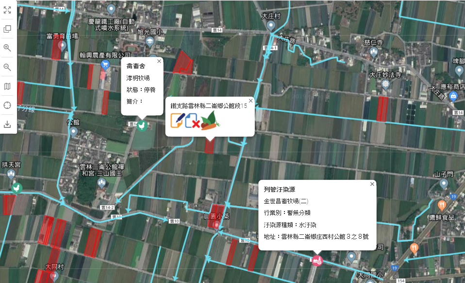 Figure 1. The land information within the 1.6 km buffer zone of lettuce farmland located in Erlun township Yunlin County, in which the channel flow, poultry house and contaminated site labeled for potential risk analysis.
The information system introduced to the lettuce industry was based on our interviews of producers with different inquiring targets from land preparation, planting to post-harvest processing. The geographic information system (GIS) is used for spatial data storage and environmental analysis. The basic layers in the systems could be overlaid with the open aerial photos to generate maps for accreditation, and the features in which are soil fertility (pH, OM, inorganic-N, Bray no.1 P, exchangeable K, exchangeable Ca, exchangeable Mg), 0.1 N HCl extractable (Cu, Zn, Cd, Cr, Ni, Pb), soil texture, and irrigation channel (position and direction). Moreover, the open data layers for potential contamination in lettuce cultivation, i.e. livestock farms, landfills, sewage treatment plants, controlled pollution sources were included in the system. Users can query analyze the potential hazards within certain buffering zone around the cultivation area such as 1.6 km by the regulation Global G.A.P. The GIS platform in the system also provides private layers enabling the users to add personal map for specific requirements.
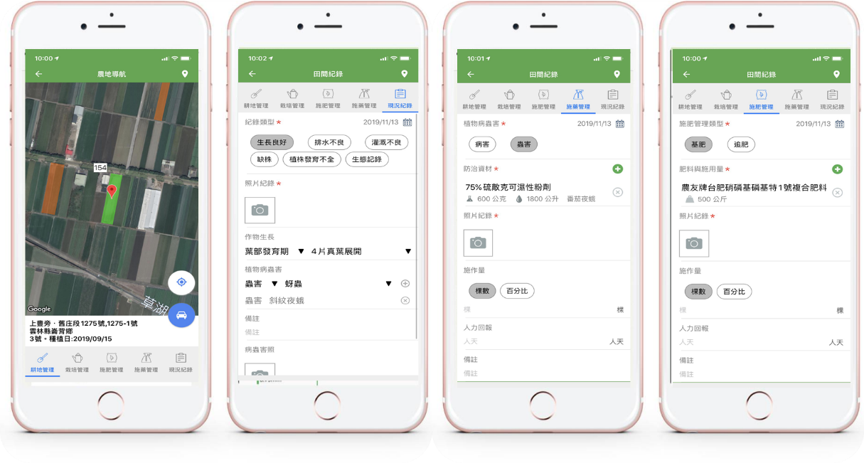 Figure 2. From left to right: the spatial map of land, field observation records, fertilizer application records and pesticide application record.
The conventional certification records are conducted in paper forms consuming time to maintain due to plenty formats and content. The introduction of mobile application for management record greatly elevates the efficiency to achieve the goal of cultivating history easily generated and informative. The geo-information of farmland is created through inputting the longitude and latitude or X, Y values under TWD 97 system, clicking on the e-map to acquire geographic information, searching by cadastral numbers, or positioning by mobile GPS. Following the first step, user can input the transplanting date, variety and tentative harvest date and acquire outputs of the basic information for the following management. The producer or industry managers can easily handle the geological distribution of the farmlands and visit to specific one by the navigation function of the application. The management details are recorded through selection in drop-down menu, picture taking or picture uploading from mobiles to formulate the information of cultivation, fertilization, pesticide application, growth stage description that reducing the time and loading of hand-writing. In order to continue the work in slow internet connection area, the application support the offline mode that user could upload records or photograph after stable internet connection within 7 days. The system were designed for the lettuce industry and providing certain flexibility for users to rearrange the content and format. The records can be review by the application or converted into csv file in batch mode for quickly review the management history in each farmland.
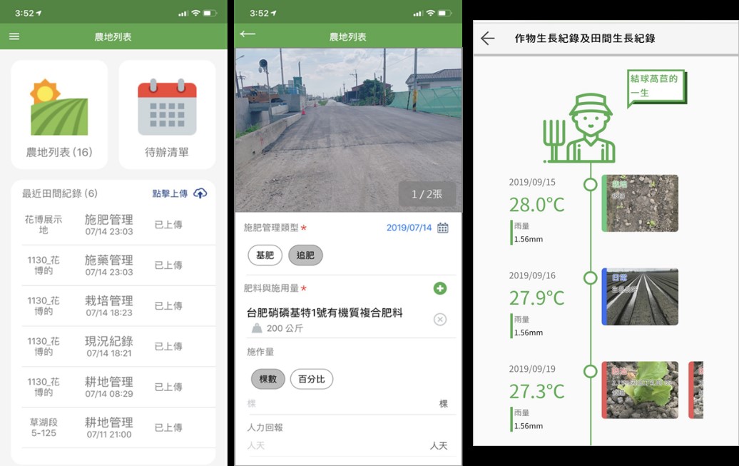 Figure 3. Reviewing the management records from the application or web page.